16.  Minimum Sector Altitude
Minimum Sector Altitude (MSA) is the lowest altitude which will provide a minimum clearance of 1,000 feet above all objects located within a sector of a circle of mostly 25 NM radius. The sector can be centered on an airport, a runway end or a navaid.
Little Navmap shows the MSA sectors are symbols attached to an airport, a runway end or a navaid.
These MSA symbols are also shown in the Tab Navaids and in tooltips on the map.
Labels shows MSA, navaid ident and radius in NM.
Sector bearings are shown in degree magnetic and sector safe altitudes shown in feet.
Disable MSA symbols in menu View -> Navaids -> Show MSA Sectors.
Right click on the MSA symbol and select Add MSA Diagram from the map context menu to show
a to scale MSA diagram. The display of user MSA diagrams is automatically enabled in menu View -> User Features ->
MSA Diagrams after using this function.
Remove MSA diagrams by clicking on the center and selecting Remove User Feature.
See also Navaids in the map legend.
Note
MSA sectors are not available when using the setting Do not use Navigraph Database in the
menu Scenery Library -> Navigraph with FSX, P3D or MSFS. See also Load Scenery Library and Navigation Databases.
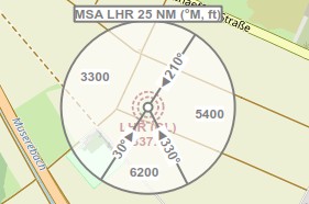
An 25 NM MSA symbol at NDB LHR having three sectors. Sectors denoted by magnetic bearing to navaid and altitudes in feet.
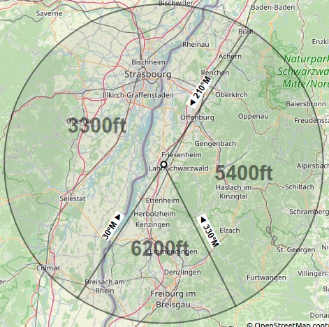
To scale MSA diagram after selecting Add MSA Diagram.