33. Procedures
33.1. General
Departure and arrival procedures will typically be used when flying an airliner, but smaller aircraft, too, have to use at least an approach procedure at their destination when flying IFR.
An airline flight containing all variations can use the following procedures or segments:
Departure airport
SID
SID Transition
en-route airway system
STAR transition
STAR
Transition to approach
Approach
Destination
A small aircraft IFR flight can use the following procedures or segments:
Departure airport
en-route airway system
Transition to approach
Approach
Destination
Note that transitions make only sense together with an approach, a SID or a STAR which will guide you to or from the runway. You can select a transition only together with the respective procedure (although the SID may be empty and consist only of a transition). If you delete a procedure from the flight plan, its transition will be deleted too.
Procedure information is saved together with a flight plan as an annotation in a LNMPLN file and will be restored by Little Navmap when loading the flight plan. Note that some export flight plan formats do not support saving of procedures.
Procedure waypoints are excluded from all flight plan formats by default. You have to use the GPS or FMS in the simulator to select procedures.
Some flightplan formats like X-Plane FMS allow saving and loading of procedures. See X-Plane FMS 11 and X-Plane 12. for more information. Transitions cannot be saved with the MSFS PLN format (see Microsoft Flight Simulator 2020).
You can enable saving of waypoints by checking Export Waypoints for Approaches and/or Export Waypoints for SID and STAR. Procedure information will be omitted if this is enabled. Note that these functions are normally not needed and can have side effects.
Note
It is not possible to assign an approach or STAR to an alternate airport. Create a new flight plan for the alternate trip if you wish to do so.
Note
FSX and Prepar3D stock data provides only approaches and transitions. SIDs and STARs are not available. These can be added by navdata updates.
33.2. 
 Set Departure Runway and Set Destination Runway
A departure and destination runway can be selected instead of an procedure.
Selecting a destination runway adds a final approach leg (runway centerline extension) which can be customized by changing altitude, length and offset angle. This allows Little Navmap to give vertical guidance and to show ILS and/or VASI slopes at the destination.
Selecting a departure runway adds a departure flight plan leg depicting the extended runway center line.
See more about this in chapter Departure and Destination Runway.
33.3. Inserting a Procedure into a Flight Plan
Right-click on an airport in the map, the airport search table, or the
flight plan table, and select Show Procedures (or
Show Departure Procedures or Show Arrival Procedures depending on airport) from the
respective context menu. This will show the tab Search Procedures in the dock window
Search.
Insert a procedure into the flight plan using the context menu in the
procedure tree view.
Right click on a procedure, a procedure leg or a transition and select
Use airport and procedure as Departure, Use airport and procedure as Destiation or
Insert Procedure into Flight Plan (substitute procedure and airport with the actual names).
You can also add a procedure from the map if using Leg Highlights on the Map or Preview all Procedures.
Right click on any waypoint of a procedure (not the leg line) and select Use airport and procedure as Departure,
Use airport and procedure as Destiation or Insert Procedure into Flight Plan.
Important
Little Navmap removes waypoints from the flight plan which overlap with the procedure.
In any case check the flight plan for reversals or zig-zag guidance. Delete waypoints manually if you find such cases.
33.4. Deleting a Procedure from a Flight Plan
Deleting a single leg from the flight plan table which is part of a procedure will remove the whole procedure and its transition. Deleting a leg being part of a transition will remove only the transition.
You can also delete procedures from the flight plan by right clicking onto a procedure waypoint on the map.
Select Delete procedure from flight plan. Substitute procedure the actual name.
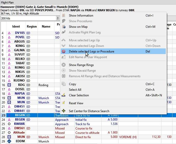
About to remove the transition MUN of the
approach RNAV BEGEN from the flight plan. Click image to enlarge.
33.5. Limitations when editing a flight plan with procedures
Deleting a leg of a procedure will remove the whole procedure from the flight plan.
You cannot move a procedure leg up or down neither can you move or add a flight plan leg into a procedure.
You cannot add waypoints in between procedures (e.g. between a STAR and an approach). Waypoints can only be added to the route between departure and arrival procedures.
You cannot add waypoints between departure airport and a SID procedure.
You cannot add waypoints between arrival procedure and destination airport.
If you delete or replace the departure airport all SID procedures are removed too.
If you delete or replace the destination airport all approach and arrival procedures are removed too.
33.6. Flying Procedures
Procedure legs are pre-calculated, with the exception of holds, turns and altitude dependent legs. This means you can fly them mostly as they are drawn on the map. If in doubt about how to fly a leg (e.g. if too many lines are overlapping) look at the procedure table in the Flight Plan Table.
33.6.1. Holds
No entry or exit procedure is shown. You have to find a proper entry procedure yourself. Holds have a straight leg flying time in minutes or a distance.
If a time is given, fly the hold as usual:
Enter at the fix using a proper entry procedure
Do a standard turn
Fly the straight leg for the given time (typically one minute)
Do standard turn
Fly to fix
Exit hold when done or instructed by ATC
Note
Do not follow the lines exactly, they are just an indicator for what to fly. An exception are holds where a distance is given for the straight leg. The hold size will match the distance in this case.
Note that procedure holds are part of the flight plan and differ from the user defined holdings ( Holdings) which are simply map display objects.
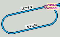
A hold with 2 NM straight segment
length. Enter and exit at ZUNAD and fly at or above 2,600 ft.
Course is 61° magnetic degrees.
33.6.2. Exiting a Hold
Little Navmap will detect when a hold is exited and advance the active leg to the next one if one of the two conditions is met:
If the next leg continues after or at the hold fix: When approaching the hold fix after one circuit continue straight on. The next leg will be activated after half a NM up to one NM.
If the next leg starts before the hold fix: Exit the hold at its fix. Exit right turn holds to the left and vice versa (i.e. turn outside the hold). Proceed to the fix of the next leg which will be activated.
You can activate the next leg manually if you do not exit the hold at
its fix. Right-click in the flight plan table on the next leg and select
Activate Flight Plan Leg.
33.6.3. Procedure turns
The flight simulator data moves the turn point of a procedure turn 10 NM out from the fix which is usually too far away.
Fly the procedure turn as usual: Minimum one minute from the fix. Use more if you need space to catch the next fix after the course reversal. Then turn using an teardrop or a standard 45/180 degree turn. Again: Follow the procedures, not the lines.
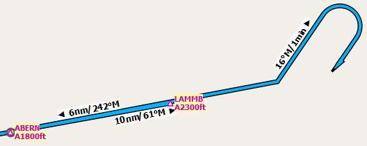
A procedure turn. Fly at least one minute outbound
61° from ABERN, turn left to 16°, fly one minute, turn 180° and fly
to LAMMB, then 242° to ABERN.
33.6.4. Distances
All procedure legs, with the exception of holds and procedure turns, are included when calculating flight distance. This means the total flight plan distance as well as the top of descent point will change when selecting an approach or a transition.
33.7. Special Leg Types
All procedure leg types (Track to Fix, Initial Fix and more)
that are shown in Little Navmap are based on the ARINC 424 path
terminator concept. A deeper knowledge of these leg types is not
important for the simulator pilot.
Four additional types are used by Little Navmap:
Start of Procedure: This leg is added if a procedure does not start with an initial fix but rather with a course, heading or track to a fix. It indicates the first position of the procedure.Proceed to Runwayin a SID: The first leg of a SID to indicate the start position on the runway. The program might fall back to the airport center if the runway is not available. The altitude restriction indicates the elevation of the runway.Straight In: Added to an approach procedure to show the course from the missed approach point (MAP) to the runway threshold. It is added when an approach ends with a runway fix. The leg has an altitude restriction 50 ft above the threshold.Circle to Land: Added to an approach procedure to show the course from the missed approach point to the airport. It is added if an approach does not end with a runway fix.Vectors: Vectors connect legs that are manually terminated by ATC with their successors which is often an initial fix.
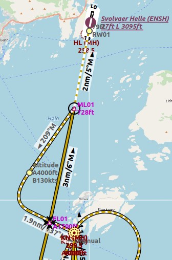
Straight In example: ENSH approach LOC FL01 (L01) to runway 01.
White/orange dotted line is the straight-in leg. ML01 is the MAP. If runway is not visible at
ML01 turn left to missed.
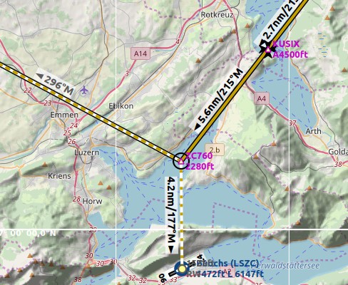
Circle to Land in example: LSZC RNAV-A KUSIX (RNVA). White/orange dotted line is the
circle-to-land leg. ZC701 is the MAP. No guidance is given for this leg. You have to navigate
around the mountain to get to runways 06 or 24.
33.8. Fix Types in a Procedure
Waypoints: Terminal waypoints or radio navaids. Some are marked as
flyoverin the approach table.Radial and distance: Example:
WIK/7nm/291°M. A fix defined by a course or heading and distance to a navaid.Distance to DME: Example:
WIK/9nm. This fix is defined by a heading or track which is terminated by reaching a DME distance.Intercept Course to Fix: Intercept a course to the next fix at an angle of about 45 degrees.Course/Heading to radial termination: Example:LPD/135°M. Turn left or right to intercept a radio navaid radial.Intercept Leg: Intercept the next approach leg at a course of about 45 degrees.Altitude: A leg or hold that is terminated by reaching a certain altitude and is used mostly on missed approaches. Since the distance depends on the aircraft, 2 NM length are used for this leg. You can ignore the line and proceed to the next leg once the altitude criteria is satisfied.Manual: Fly a heading, track or a hold until manually terminated by ATC.
Runway fixes are prefixed with RW. They usually have an altitude
restriction a few ft above the runway. Higher altitude restrictions
(i.e. > 500 ft) indicate a circling approach.
33.9. Altitude and Speed Restrictions
Restrictions are shown on the map and in the flight plan table.
Number only: Fly at altitude or speed. Map examples:
5400ftor210kts.Prefix
A: Fly at or above altitude or speed. Map example:A1800ftorA200kts.Prefix
B: Fly at or below altitude or speed. Map example:B10000ftorB240kts.Range: Fly at or above the first altitude and at or below the second altitude. Map example:
A8000B10000ft. Same for speed.Prefix
GS: Not an altitude restriction but an indicator for the ILS glideslope altitude. Can meanatorat or above.Vertical path
-3.2°: A vertial path angle which has to be followed. Calculated paths are shown with a white text background and required paths with a yellow backgroud.
33.11. Missed Approaches
Missed approach legs are activated once the simulator aircraft passes the last point of an approach and the missed approach is shown on the map. The display of remaining flight plan distance will switch to display of remaining distance to last missed approach leg.
33.12. Leg Highlights on the Map
Up to three points will be highlighted when clicking on a procedure leg in the tree in the search window:
A small blue circle shows the beginning of the leg.
The end of the leg is shown by a large blue circle.
A thin circle shows the location of the recommended or related fix if available.
33.13. Invalid Data
A leg entry will drawn red if a navaid was not resolved during the scenery database loading process. This happens only when the source data is not valid or incomplete. In this case, the resulting procedure is not usable and a warning dialog will be shown if essential navaids are missing.
Little Navmap might refuse to use the procedure depending on error.