56. Navigation Databases
Little Navmap can use up to two databases in parallel:
Simulator database: Created by reading the scenery library of FSX, Prepar3D, Microsoft Flight Simulator 2020, Microsoft Flight Simulator 2024 or X-Plane.
Navigation database: Provided by Navigraph. Does not have to be compiled and can be updated by the Navigraph FMS Data Manager to the latest AIRAC cycle.
Little Navmap is bundled with a navigation database courtesy of Navigraph which is enabled per default.
You can see the data source for each navaid or airport in the section Data Source in the information window (see Data Sources).
Tip
You can update the navigation database of Little Navmap with the Navigraph FMS Data Manager. See Install Navigraph Updates on my home page for more information if the update fails.
Note
Note that runway numbers shown in the procedure search or context menus might differ compared to the airport runways. This happens when an add-on airport and the navigation data have different runway numbers which is a result of renumbered runways due to changes in magnetic declination (magnetic pole drift).
Little Navmap resolves these mismatches internally and still allows to work with procedures. You might expect issues when loading flight plans containing such discrepancies into add-on aircraft or simulators.
Important
It is recommended to keep all scenery libraries in sync. This means that your simulator, Little Navmap, aircraft, tools and websites should use the same AIRAC cycle. Having navdata synchronized helps to avoid potential issues when loading flight plans.
The problem when exchanging flight plans across applications is that waypoints, airways and procedures like SIDs, STARs, and approaches change over time.
A SID WENAS7 becomes WENAS8, waypoints/intersections are removed, the airway structure changes or runways are renamed, for example.
The AIRAC cycles that contain the Navdata are updated every 28 days. If some applications are updated and others are not, this may result in inconsistencies between Little Navmap, flight planning websites, or other programs.
Warning
Always close Little Navmap before updating or copying its databases.
Three display modes can be selected from the menu Scenery Library as
shown below.
56.1. Select Automatically
This is the default recommended mode which selects the navdata sources from the three modes below based on the used simulator and AIRAC cycles.
Read below if you’d like select the navdata mode manually.
56.2. Use Navigraph for all Features
Uses only information from the Navigraph database. This mode is selected automatically if the navigation database in the simulator is empty, i.e. if you have not loaded the scenery library for the simulator.
Note
Note that airport information is limited in this mode. This means that aprons, taxiways, parking positions, runway surface information and fuel information are not available. Additionally, smaller airports might be missing.
Runway layout might not match the runway layout in the simulator if you use stock or older airport scenery.
An advantage of this mode is that approach procedures always match the airport runway layout precisely.
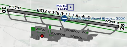
Airport diagram for EDDN from simulator scenery
(X-Plane) as shown in the modes Do not use Navigraph Database or
Use Navigraph for Navaids and Procedures.
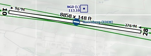
Airport EDDN from the Navigraph database while
Use Navigraph for all Features is enabled. Note missing runway
surface information, aprons, taxiways and parking positions.
56.3. Use Navigraph for Navaids and Procedures
This mode blends navaids and other features from the Navigraph database with the simulator database. This affects the map display, all information windows and all search windows.
The following features are taken from the simulator database when using this mode:
Airports (also
Searchdock window, tabAirport)Aprons
Taxiways
Parking positions
Airport COM frequencies
The purpose of using the simulator airport is to provide more detailed information, such as the layout of the apron and taxiways. Furthermore, the airport layout shown in Little Navmap should match what you see in the simulator, even if you use an outdated airport add-on or an outdated stock airport. It would not make sense to show a real-world airport layout that does not match what you see in the simulator.
The following features are taken from the Navigraph database:
Navaids (waypoints/intersections, VOR, NDB, marker, ILS and more) which affects:
Searchdock window, tabNavaidFlight plan calculation
Route Description
MORA grid ( Show Minimum off-route Altitude Grid)
Airport MSA sectors ( Show MSA Sectors)
En-route holdings ( Show Holdings)
GLS/RNV glidepaths ( Show GLS/RNP Approach Paths)
Procedures (approaches, SIDs and STARs). This affects:
Searchdock window, tabProceduresand loading and display of procedures from flight plans.
Airways
56.3.1. Limitations in this mode
Little Navmap will try to resolve mismatches between procedures and runways due to airport updates and will display a warning in the Search Procedures (Runway Mismatches between Simulator and Navigation Data). Update an airport using payware or freeware scenery if you find that an approach or departure procedure does not start at a runway end of an airport.
Procedures cannot be recognized when selecting
Show Proceduresin the menu if an airport has changed its ICAO ident (e.g.Kulik Lake: ident changed fromLKKtoPAKL). If you suspect such a case use the modeUse Navigraph for all Featuresto get the procedures for the airport.The airport search only considers procedures available in the simulator. Switch to
Use Navigraph for all Featuresto look for airports that have procedures from the Navigraph database.
Tip
Use the Navigraph navdata update for Microsoft Flight Simulator 2020 or 2024 to update the scenery library to the latest and also to keep Little Navmap and MSFS navdata synchronized. This will reduce issues when loading flight plans into the simulator. See also Microsoft Flight Simulator 2020, 2024 Airports and Navdata.
Using the fsAerodata navdata for FSX or P3D update will remove many of the limitations above since it will synchronize the simulator scenery with the Navigraph database.
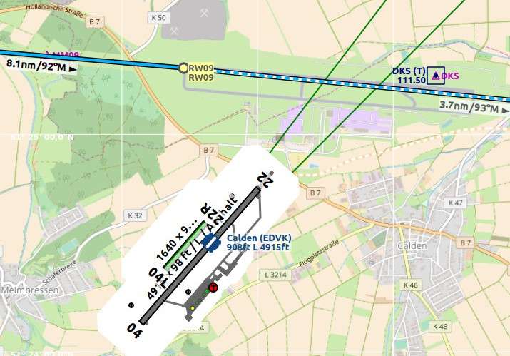
An extreme example for runway/procedure mismatch. The approach from the Navigraph database cycle 1707 ends at the not visible runway 09 while the outdated scenery from FSX shows the airport at the wrong position. EDVK was rebuild north of Calden in 2013. The OpenStreetMap background shows the new airport. Click image to enlarge.