67. Coordinate Formats
This chapter briefly describes the recognized coordinate formats in flight plan position dialogs and userpoint dialogs.
The input field shows a message below which indicates if the coordinates
were recognized and shows the translated coordinates in the preset
format as selected in dialog Options on page Units. A red message
is shown in case of error.
Check the displayed translated coordinates to verify that your input was parsed correctly.
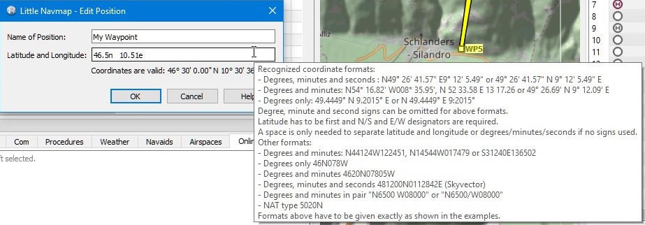
Editing an user defined flight plan position. Tooltip gives a quick help on coordinate formats.
67.1. General
Latitude has to be first and longitude second.
N/S and E/W designators are required except for the signed formats. Case does not matter.
Degree, minute and second signs can be omitted if numbers are separated by spaces.
A space is only required to separate latitude and longitude or degrees/minutes/seconds if no unit signs are used.
Decimal separator can be period (English) or the locale dependent separator like e.g. comma (German).
ARINC 424 Code Convention full degree waypoint formats like
57N30,5730Eor57S30can be read.
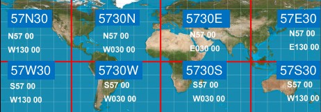
Full degree coordinate conventions, examples and respective quadrants.
All dialogs show the read coordinates below the input field in the curretly configured coordinate format. See Units for more information.
Tip
You can directly paste coordinates from the Wikipedia like 40°41′21″N 74°2′40″W into the fields.
67.2. Signed Decimal Formats
For the coordinate formats Latitude and Longitude with sign and
Longitude and Latitude with sign:
Latitude: Negative is south and positive is north.
Longitude: Negative is west and positive is east values.
Selecting these display formats will also enable input of signed decimal values.
Comma separated values like 50,07477,8,54053 (comma as German decimal separator) or 50.07477,8.54053 are valid. Spaces before and after the comma are allowed.
Note
The reading order for coordinates (Latitude and Longitude versus Longitude and Latitude)
will also change depending on the selected format if entering signed numbers.
The reading order will not change if the input field uses N, S, E and W designators.
67.3. Other Formats
These have to be given exactly as shown in the examples.
Degrees and minutes:
N44124W122451,N14544W017479orS31240E136502Degrees only
46N078WDegrees and minutes
4620N07805WDegrees, minutes and seconds
481200N0112842E(SkyVector)Degrees and minutes in pair
N6500 W08000orN6500/W08000NAT type
5020N
67.4. Examples
Degrees, minutes and seconds:
N49° 26' 41.57" E9° 12' 5.49"or49° 26' 41.57" N 9° 12' 5.49" EDegrees and decimal minutes:
N54* 16.82' W008* 35.95',N 52 33.58 E 13 17.26or49° 26.69' N 9° 12.09' EDecimal degrees only:
49.4449° N 9.2015° EorN 49.4449° E 9:2015°ARINC 424 Code Convention full degree waypoint format:
57N30,5730Eor57S30