10. Statusbar
The statusbar at the bottom of the window shows various information.
Shown or hide it in the menu Window -> Statusbar.
The statusbar at the bottom of the main window shows various indications (from left to right):
- Messages, last action or quick help
explaining a menu item or toolbar button. When inactive the field shows the number of messages, if any. Messages cover background tasks like weather updates or the simulator connection state. Messages are shown in the tooltip when clicking into the field or hovering the mouse above. A maximum of ten messages is shown.
- Connection status
for a local or remote connection. The tooltip provides more detail about the status, like the host name for remote connections as well as the connection status for online networks.
Connecting...: The program is trying to establish a connection which was initiated either manually or automatically.Connected: A connection was established.Disconnected: The simulator or Little Navconnect exited.
- Map content indicator
that shows airport types, airspaces, navaids or AI vehicles currently visible on the map. The tooltip gives more details.
A red warning message
Too many objectsis be shown if too many objects are displayed on the map due to too high a detail level. The map display might be incomplete if this happens.A red
Database emptymessage will be shown if the currently selected database has no content and needs to be loaded. See Load Scenery Library for more information how to load the scenery library for a simulator.
- Map detail level.
Range is -2 for least detail to +5 for most detail. See More Details, Less Details and Default Details in menu
View.- Online map download progress indicator.
This shows the state of the current map download. The text is prefixed with a red
Offline.indication if offline mode is enabled.Done: All map data loaded successfully.Loading: Map data is missing in the cache and was requested. Now waiting for reply.Updating: Map data is already loaded but expired after two weeks. Waiting for new data after requesting an update.Incomplete: Download failed.
- Zoom distance
viewpoint distance to earth surface in NM or kilometers.
- Coordinates
at cursor position on map as latitude and longitude depending on selected unit in the dialog
Optionson page Units.Ground elevation below the cursor after a short delay if the GLOBE offline elevation data is selected. See Install GLOBE elevation data.
Magnetic declination at the cursor position in degrees West or East. See also Magnetic Declination for more information.
- Current date of month and UTC time
hours:minutes:seconds. This is the real world time and not the simulator time. The tooltip gives more date and time information.
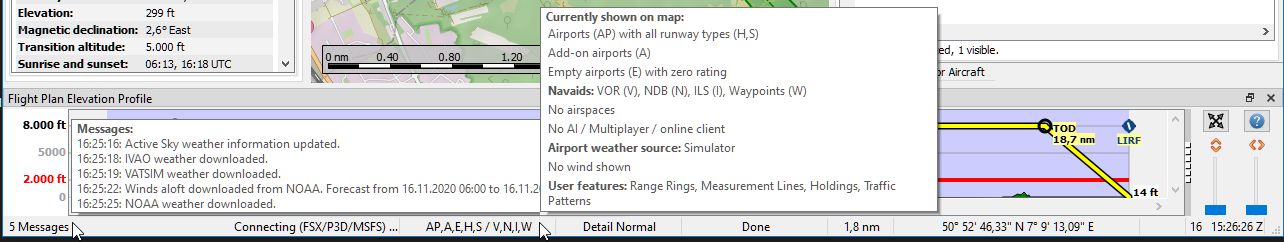
Status bar with messages in tooltip about the last weather updates,
the connection status Connecting (FSX/P3D/MSFS)
and a tooltip that indicates what is currently shown on the map. The map
detail level is unchanged and the map coordinates at the cursor position
are shown on the bottom right. Altitude at cursor is not shown since
offline elevation data is not installed. The online map download progress
indicator shows Done indicating all map tiles were downloaded. Zoom
distance is 1.8 NM.